
Metrolink map
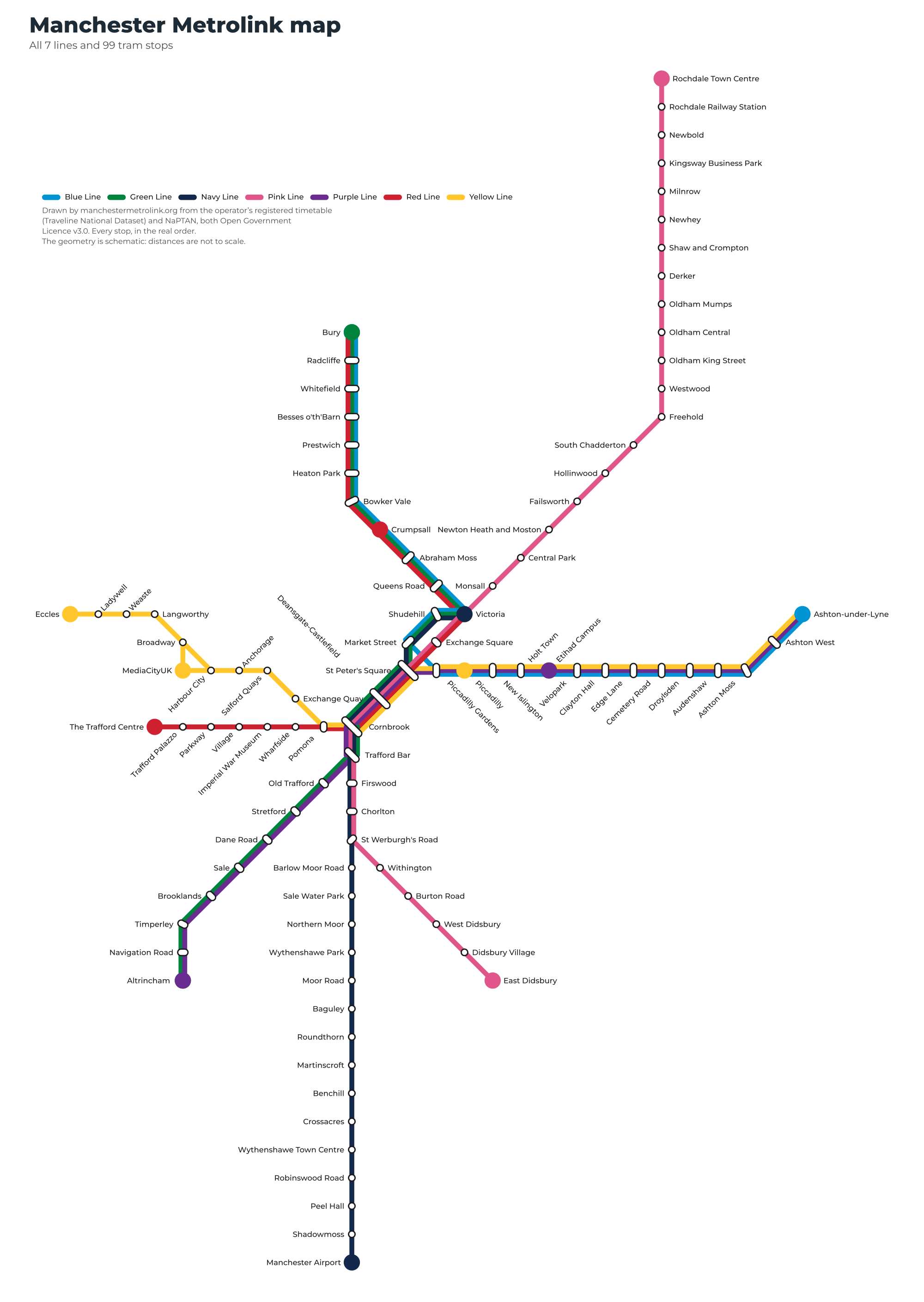
All 99 stops and 7 lines on one sheet — a schematic diagram drawn from the published data, free to download as a PDF.
The map as a PDF
How this map is made
It is not the operator’s map touched up. It is drawn from the data: all 99 stops, the order of every line and the shape of every route come from the operator’s own registered timetable and from NaPTAN, the Department for Transport’s stop register. Both are open data, which is precisely why this sheet can be published, downloaded and printed without anyone’s permission.
It is a schematic diagram, in the tradition Harry Beck started with the Tube map in 1933: every stretch of track runs at 0°, 45° or 90° and the stops are evenly spaced. That is a trade, and it is worth saying plainly — distances are not to scale. What you get back is a sheet you can read: Manchester Airport and Rochdale are 40 km apart and a third of the network is packed into two square kilometres of city centre, so a true-to-scale map turns the middle into a knot. North is still at the top and no leg points more than 45° away from the direction it really runs in.
One thing most maps of Manchester gloss over and this one does not: MediaCityUK is a spur, not a through stop on the main Eccles run, and more Yellow Line trams terminate there than carry on to Eccles. The Yellow Line page has the split.
The seven lines
Where you can change lines
35 of the 99 stops are shared by two or more lines.
Questions about the map
Yes — the button above downloads one. It is a vector PDF, so it prints at any size without going fuzzy.
Not yet, and we would rather say so than guess. Metrolink fares work by zone, but the operator’s zone table is not available to us as open data, and the third-party versions on the web contradict each other. What we can say about tickets is on its own page.
Yes. It is our own work, published under CC BY 4.0: use it anywhere, including commercially, as long as you credit manchestermetrolink.org.
It is built from the timetable in force from 2026-11-09. If the network changes, the map is regenerated from the new data rather than edited by hand, so it cannot drift out of step with the stop list.
On this page
Tram times on this page come from the Traveline National Dataset (TransXChange, Open Government Licence v3.0); stop names and coordinates from NaPTAN, the Department for Transport stop register. Manchester Metrolink is an independent guide: it is not run by Metrolink or Transport for Greater Manchester (TfGM) and has no connection with either. Check tfgm.com before you travel.